An Asteroid a Few Miles Wide That Hit Earth: 66 million years ago wiped out nearly all the dinosaurs and nearly three-quarters of the planet's plant and animal species.
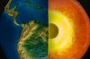
An asteroid a few miles wide that hit Earth 66 million years ago wiped out nearly all the dinosaurs and nearly three-quarters of the planet's plant and animal species.
It also triggered a devastating tsunami with mile-high waves that washed over the ocean floor thousands of miles from the impact site on Mexico's Yucatan Peninsula, according to a new study led by the University of Michigan.
The study, scheduled for online publication Oct. 4 in the AGU Advances journal, presents the first global simulation of a Chicxulub impact tsunami published in a peer-reviewed scientific journal. The U-M researchers reviewed the geologic record at more than 100 sites around the world and found evidence that supports their models' predictions about tsunami path and power.
These tsunamis are strong enough to disturb sediments in ocean basins around the world. That leaves a gap in the sedimentary record, or a glob of older sediments, said lead author Molly Range, who conducted the modeling study for her master's thesis
.jpg "An Asteroid")
A review of the geologic record focused on "boundary segments" of marine sediments deposited before or after asteroid impact and the K-Pg mass extinction after the close of the Cretaceous period. The distribution of shear and breaks we observed in Upper Cretaceous marine sediments is consistent with our model results, which model gives us more confidence in the predictions says Range, who started the project as an undergraduate in Orbic's lab. Department of Earth and Environmental Sciences.
The study authors calculated that the tsunami had an impact 30,000 times the force of the December 2004 Indian Ocean earthquake, which killed more than 230,000 people and was one of the largest tsunamis on modern record.
The team's simulations show that the impact tsunami propagated mainly east and northeast into the North Atlantic Ocean and southwest into the South Pacific Ocean through the Central American Seaway (used to separate North and South America).
In those basins and some adjacent areas, underwater current speeds can exceed 20 centimeters per second (0.4 mph), a speed strong enough to erode fine-grained sediments from the seafloor.
In contrast, the team's simulation shows that the South Atlantic, North Pacific, Indian Ocean and today's Mediterranean region are largely protected from the strong effects of the tsunami. Modeled current velocities at those locations may be below the 20 cm/s threshold.
.jpg "An Asteroid")
For a review of the geologic record, U-M's Moore analyzed published records of 165 marine boundary segments and was able to obtain useful information from 120 of them. Most sediment come from cores collected during scientific ocean-drilling projects.
The North Atlantic and South Pacific have the fewest sites with completely undisturbed K-Pg boundary sediments. In contrast, the largest number of complete K-Pg boundary segments is found in the South Atlantic, North Pacific, and Indian Ocean and Mediterranean regions.
We found confirmation in the geologic record for areas where maximum impact was predicted in the open ocean said Arbic, a professor of earth and environmental sciences who oversaw the project. The geologic evidence certainly strengthens the paper.
Of particular importance, according to the authors, are outcrops of the K-Pg boundary on the east coast of New Zealand's North and South Islands, more than 12,000 kilometers (7,500 mi) from the Yucatan impact site.
The heavily disturbed and incomplete New Zealand sediments, known as olistostromal deposits, are thought to be the result of local tectonic activity. But based on the age of the deposits and their location directly in the model path of the Chicxulub impact tsunami, the U-M-led research team suspects a different origin.
We think these deposits record the effects of a tsunami impact, and this is perhaps the most confirmation of the global importance of this event," said Range.
The study used a two-step strategy. First, a large computer program called Hydro code simulated the chaotic first 10 minutes of the event, including tsunami impact, crater formation, and initiation. The work was conducted by co-author Brandon Johnson of Purdue University.
Based on the results of previous studies, the researchers modeled an asteroid with a diameter of 14 kilometers (8.7 miles) moving at a speed of 12 kilometers (27,000 mph) per second. It struck the granitic crust covered by thick sediments and shallow ocean waters, leaving a roughly 100-kilometer-wide (62-mile-wide) crater and spewing thick clouds of soot and dust into the atmosphere.
Two and a half minutes after the asteroid hit, a curtain of ejected material pushed a wall of water away from the impact site, briefly forming a 4.5-kilometer-high (2.8-mile-high) wave as the ejecta fell back. the land
Ten minutes after the projectile hit the Yucatan, 220 kilometers (137 mi) from the point of impact, a 1.5-kilometer-high (0.93-mi-high) tsunami wave began to ripple in the shape of a ring and propagate outward.
At the 10-minute mark, the results of Johnson's iSALE hydrocode simulations were entered into two tsunami propagation models, MOM6 and MOST, to track massive waves across the ocean. MOM6 is used to model tsunamis in the deep ocean, and NOAA uses the most model for tsunami forecasts at its tsunami warning centers.
The big result here is that two global models with different formulations produced nearly identical results, and geologic data on both complete and incomplete segments are consistent with those results said Moore
After one hour impact the tsunami spread out of the Gulf of Mexico and into the North Atlantic. Four hours after impact the waves moved through the Central American Seaway and into the Pacific. Twenty-four hours after the collision the waves crossed most of the Pacific from the east and most of the Atlantic from the west and entered the Indian Ocean from both sides. After 48 hours impact significant tsunami waves had reached most of the world's coastlines.
The study models suggest that open ocean wave heights in the Gulf of Mexico exceed 100 meters (328 ft), with wave heights in excess of 10 meters (32.8 ft) as the tsunami approaches the North Atlantic coast and southern portions.
As the tsunami approaches those coastlines and encounters shallower bottom waters, wave heights increase dramatically through a process called shoaling. Current velocities exceed the threshold of 20 centimeters per second for most coastal areas around the world.
Depending on the geometry of the coast and advancing waves, most coastal areas are subject to inundation and some degree of erosion, the study authors said.
Story Source:
Materials provided by University of Michigan.
Note: Content is also emended for vogue and length
Know Sedimentary Basin
Visit Official Home Page


.jpg&description=An Asteroid a Few Miles Wide That Hit Earth)
0 Comments